Preprints
Stochastic Modelling of Thermokarst Lakes: Size Distributions and Dynamic Regimes
Thermokarst lakes are common and dynamic features in lowland areas with ice-rich permafrost, playing a crucial role in the exchange of carbon, water, and energy between atmosphere and land surface. They are vital to Arctic lowland hydrology, yet they are often not well-represented in Earth system models (ESMs). Most modeling efforts have focused on individual lakes, because thermokarst lake dynamics depend on small-scale surface and subsurface variations that are hard to measure. This makes deterministic modelling challenging. We instead use a probabilistic modeling approach, incorporating randomness to reflect the diverse behaviors of individual lakes due to varying environmental conditions. We present idealized simulations and test new high-resolution remote sensing data that track annual lake areas, which help in initializing and calibrating our model. While our model marks a step forward in representing permafrost landscapes in ESMs, our research also highlights the need for ongoing remote sensing data collection and additional data on past lake behaviors to improve model accuracy.
Enhanced prescription of soil organic and mineral content in the ORCHIDEE LSM to better simulate soil temperatures: application at nine high-latitude GEM and FLUXNET sites
In this study, we improved the ORCHIDEE LSM by using detailed global soil data from a high-resolution database called SoilGrids. This allowed us to better prescribe soil organic and mineral content and to refine the modelling of heat transfer and soil temperatures. We tested this updated model at various instrumented Arctic and boreal sites and compared it to earlier versions. Results showed that including detailed organic matter data improved soil temperature predictions, especially in deeper layers and during snow-free periods, increasing accuracy by up to 25% in some cases. This underscores the value of precise soil data for better climate predictions, particularly in Arctic and boreal regions where organic-rich soils play a key role in the ecosystem.
The Boundary Layer Dispersion and Footprint Model: A fast numerical solver of the Eulerian steady-state advection-diffusion equation
The Boundary Layer Dispersion and Footprint Model (BLDFM) is a new, accurate tool that tracks how greenhouse gases and pollutants spread in the air. It uses advanced numerical methods without relying on simplifying assumptions like traditional models. The model is flexible and works well with different turbulence data or real wind measurements. Tests show it matches exact specific solutions and improves on older models by including more detailed mixing processes. BLDFM is useful for climate studies, pollution monitoring, and understanding emission sources.
If the Yedoma thaws, will we notice? Quantifying detection limits of top-down methane monitoring infrastructures
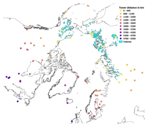
In this observing system simulation experiment (OSSE), we examined the capabilities of three atmospheric GHG monitoring platforms i.e. tall towers, and the TROPOMI and MERLIN satellites, to detect changes in CH4 release from increased Yedoma thaw. For this OSSE, a set of scenarios are simulated In a virtual environment with the GEOS-5 model: one representing a 'natural' emission case as the reference, and a second featuring enhanced CH4 release from Yedoma soils. From within these modelled environments, synthetic measurements are generated following best in situ practices and realistic error characterizations. We find the overall highest sensitivity to detect raised Yedoma emissions from the satellite platforms, while results for the tower network varied widely, but was highly dependent on transport modelling uncertainties. Overall, the individual systems appear to lack the ability to detect and attribute small changes in Yedoma CH4 fluxes, and would either need to be used in combination or require a considerable time to detect changes under higher emission scenarios.
Publications
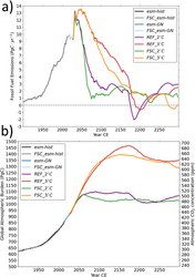
Permafrost Thaw Impact on Remaining Carbon Budgets and Emissions Pathways in 2°C and 3°C Global Warming Scenarios
High-latitude frozen soils contain a large amount of organic matter that could release greenhouse gases as permafrost thaws. This study uses a climate model to explore how thawing permafrost affects efforts to limit global warming to 2°C and 3°C above preindustrial levels. The research finds that thawing permafrost and the deepening of the active layer make an additional 120 PgC (for 2°C warming) and 230 PgC (for 3°C warming) available for decomposition into greenhouse gases. In both cases, about 75% of that carbon reaches the atmosphere as carbon dioxide by the year 2300. This release reduces the remaining carbon budget by about 13% for the 2°C and 11% for the 3°C warming scenarios. Permafrost emissions could average 0.3 to 0.7 PgC per year, with temporary peaks possible. Notably, negative emissions are needed for the 3°C scenario when considering permafrost carbon, highlighting the importance of including permafrost emissions in climate mitigation strategies.
New meta-dataset of Arctic greenhouse gas observations available
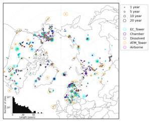
Greehouse gas observations in Arctic ecosystems remain scarce and a network across measurement techniques does not exist to date. In this study, we present a meta-dataset of ARctic greenhouse Gas Observations (ARGO) including information about sites where greenhouse gases were measured across different measurement techniques and ecosystems. This dataset provides a novel repository for metadata to facilitate synthesis efforts for regions experiencing rapid environmental change. The meta-dataset visualises where measurements lack and will be updated as new observations are made public.
Permafrost thaw: Gradual change or climate tipping point?
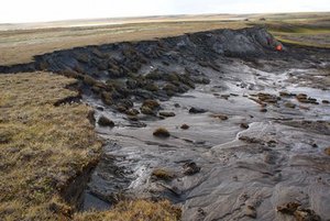
Global warming leads to Arctic permafrost thaw and the subsequent release of carbon dioxide and methane into the atmosphere. These changes are considered irreversible and, in some cases, abrupt, which has led to discussion whether permafrost might be a tipping element in the climate system. Researchers have compiled the currently available knowledge on how permafrost responds to climate change. They concluded that changes in permafrost are gradual at the global scale but abrupt on a local scale, and that the loss of carbon is irreversible.
Permafrost and Freshwater Systems in the Arctic as Tipping Elements of the Climate System
The Arctic is warming several times faster than the rest of the globe. Such Arctic amplification rapidly changes hydrometeorological conditions with consequences for the structuring of cold-adapted terrestrial and aquatic ecosystems. Arctic ecosystems are particularly susceptible to hydrometeorological regime shifts thus frequently undergo system-scale transitions. Abrupt ecosystem changes are often triggered by disturbances and extreme events that shift the ecosystem state beyond its buffering threshold capacity thus irreversibly changing its functioning (ecosystem tipping). The tipping depends on spatial and temporal scales. Due to the centennial timescale of soil carbon and vegetation dynamics, Arctic ecosystems are not in equilibrium with the changing climate, so a tipping could occur at a later time. Earth Observation (EO) is useful for monitoring ongoing changes in permafrost and freshwater systems, in particular extreme events and disturbances, as indicators of a possible tipping point.
InSAR-derived seasonal subsidence reflects spatial soil moisture patterns in Arctic lowland permafrost regions
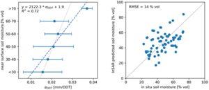
Mapping soil moisture in Arctic permafrost regions is crucial for various activities, but it is challenging with typical satellite methods due to the landscape's diversity. Seasonal freezing and thawing cause the ground to periodically rise and subside. Our research demonstrates that this seasonal ground settlement, measured with Sentinel-1 satellite data, is larger in areas with wetter soils. This method helps to monitor permafrost degradation.
Advancing the Arctic Methane Permafrost Challenge (AMPAC) With Future Satellite Missions
Key variables observable from space include methane concentrations as well as landcover properties to inform process-based models as proxy for sources as well as temperature-related constraints for microbial activity. Upcoming missions are expected to advance these capabilities significantly with increased sampling intervals through future synthetic aperture radar missions and constellations of multiple multispectral sensors. This will allow better representation of seasonality and advance methane source attribution in general. In addition, continuity of current missions, which provide GHG observations, including methane, is crucial.
The precarious future of permafrost
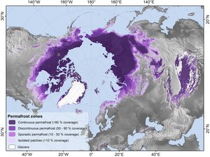
The Arctic is heating up particularly fast as a result of global warming – with serious consequences. The widespread permafrost in this region, where soils currently store twice as much carbon as the atmosphere, is thawing. Scientists are using increasingly detailed climate models to investigate what this means for the global climate and which striking feedbacks need to be taken into account.
High-Latitude Eddy Covariance Temporal Network Design and Optimization
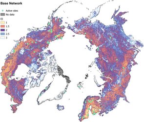
Ecosystems at high latitudes are changing rapidly in response to climate change. To understand changes in carbon fluxes across seasonal to multi-decadal timescales, long-term in situ measurements from eddy covariance (EC) networks are needed. Since most regions of the Arctic are remote, and climate conditions are often extreme, continuous operation of EC sites is challenging, and as a consequence the Arctic network is comparatively sparse and might not cover all essential regions. This study investigates how well the current EC network represents the Arctic, and where there might be coverage gaps both in space and time. We find that it is essential to keep currently active EC sites running since if we were to stop measurements our ability to predict this carbon release would not only stagnate but rapidly decline. We developed a method to identify regions that are underrepresented and by incorporating expert knowledge and a new optimization algorithm we show ideal locations to expand the monitoring network, to better prepare for the future.
Land cover succession for recently drained lakes in permafrost on the Yamal Peninsula, Western Siberia
Lakes are common features in Arctic permafrost areas. Land cover change following drainage needs to be monitored due to its ecological implications and effects on the carbon cycle, particularly regarding transitions between wet and dry conditions. Satellite data are key in this context. We compared a common vegetation index approach with a novel land-cover-monitoring scheme. Land cover information provides specific information on wetland features. We also showed that the bioclimatic gradients play a significant role after drainage within the first 10 years.
Large Eddy Simulations of the Interaction Between the Atmospheric Boundary Layer and Degrading Arctic Permafrost
The study explores how thawing permafrost could change the Earth's surface structure in the Arctic region. We used advanced simulations (Large Eddy Simulations) to study how different types of surfaces, like grassland and lakes, affect the atmosphere above. It was found that the proportion of lakes in the area has a big impact on the heat exchange with the atmosphere, suggesting a potential feedback mechanism: as the Arctic dries due to climate change, it might speed up permafrost thaw. Additionally, the study highlights that the arrangement of surface features matters, which is important for Earth System Models predicting permafrost changes in the Arctic.
Climate change amplified by permafrost cloud feedback
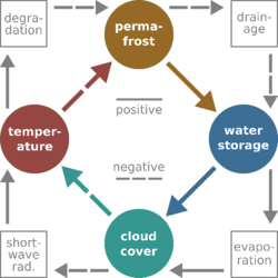
Researchers at the Max Planck Institute for Meteorology shed light on what may happen if the frozen soils thaw in response to global heating. Landscapes in the Arctic and subarctic zone are often very wet with water saturated soils and an extensive lake- and wetland cover shaping the moisture and energy exchange with the atmosphere. To some extent, the abundance of water is caused by the presence of permafrost, that is those parts of the ground that remain perennially frozen. Such soil layers have underlain large parts of the region since the last glacial maximum and strongly inhibit the movement of water below the surface.
Russian collaboration loss risks permafrost carbon emissions network
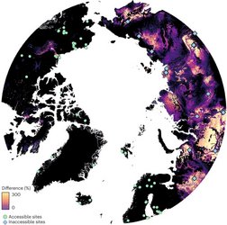
The Russian Federation contains two-thirds of the northern permafrost area. The loss of access to permafrost carbon flux sites and data within Russia, linked to the Russian invasion of Ukraine, threatens the ability of the international science community to detect and quantify the current state of the permafrost-climate feedback. This disruption of science collaboration undermines the effectiveness of the Arctic carbon monitoring network as a tool for monitoring climate change in quantifiable ways. This study found that the representativeness of the pan-Arctic network of eddy covariance flux towers is reduced to about 66% of its full impact when removing the 27 sites located in Russian territory. This loss can only partly be compensated for when installing new sites in Arctic regions outside of Russia. Expanding e.g. North American infrastructure could be shown to be a way forward for climate science, and also satellite remote sensing observations may partly fill the gap, but since there are permafrost ecosystems in Russia that do not have environmental analogs elsewhere, there does not appear to exist an equivalent solution to Russian science collaboration.
